Pages

Thursday, October 29, 2015

Natore rajbari bangladesh


Image result for natore rajbari bangladesh

Natore rajbari bangladesh

Natore Rajbari (also known as Pagla Raja's Palace, Natore Palace) was a prominent royal palace in Natore, Bangladesh. It was the residence and seat of the Rajshahi Raj family of zamindars. Famous queen Rani Bhabani lived here and after the death of her husband, expanded both the estate and the palace.This block contains twelve spacious apartments,disposed on either side of the large reception hall(7.47m × 16.01m) which is located in the middle.The access to the reception hall(60'-0"x 30'-0") is gained through another large hall and is backed by a 10'-0" wide veranda on the north. The lofty ceiling of the central hall, rises to a height of 30'-0" and is lit by eighteen clerestory windows, originally fitted with colored glass panes, whilst the roof of the other rooms are considerably lower in height. The entire floor of this block is laid in black and white imported marble. The back veranda is supported on twenty pairs of Corinthian columns,the capitals of which contain within its acanthus leaves, some classical nude female figures.The western block,placed at right angles to the main block,has about a 200'-0" frontage and faces the lawn on the east. It is also a single-storied building with an arched projecting bay in the middle.A strip of veranda,supported on a series of paired Doric columns, runs the entire length of the block.Entering through the arched central bay there is access into an open ob longed court,occupied by typical 'nat-mandap'. Beyond and further to the west, is a Krishna temple. This family shrine has a 50’-0” wide frontage, backed by a 10’-0” wide veranda which carried on a series of double Corinthian columns. Natore Zamindars was one of the largest Zamindaris of Bengal. The originators of this Zamindari were Ramjivan and Raghunandan both sons of Kamdev. Ramjivan's daughter-in-law was Rani Bhawani(1716-1795), a legendary name in Bengal politics in the 18th century and an endearing personality in everyhome of the country due to her boundless generosity and public spirit. After becoming Zamindar Ramjivan built his Rajbari at Natore occupying a huge area of 50.42 acres of land and it is enclosed within two rings of defensive moats-one within the other.The moats are now dotted with large tanks,orchards and flower gardens surrounding the derelict ruins of the seven surviving detached palaces. Of these only four deserve description while the rest are in advanced stage of disintegration and are of no architectural significance.After the death of the great queen, her adopted son Ramkrishna ruled the area. After his death, his two sons Sibnath and Vishwanath became the co-sharers of the Natore Zamindari in 1778. The whole Zamindari was divided between them, and the part of the eldest son was known as "Boro Taraf" and the part of the youngest son was known as "Chhoto Taraf". The Rajbari was protected on all sides by ditches. There were nine buildings in this Rajbari. They are the palace of Boro Taraf, The palace of Choto Taraf, Kachari Bhavan and Guard House of Boro taraf, Kachari Bhavan of Choto Taraf, Rani Bhavan, Guest House, Madhu Rani Bhavan etc.
Wednesday, October 28, 2015

St. Martin's Island in Bangladesh.


 Image result for saint martin's island

St. Martin's Island is a small island (area only 8 km2) in the northeastern part of the Bay of Bengal, about 9 km south of the tip of the Cox's Bazar-Teknaf peninsula, and forming the southernmost part of Bangladesh. There is a small adjoining island that is separated at high tide, called Chhera island. It is about 8 km west of the northwest coast of Myanmar, at the mouth of the Naf River. The first settlement started just 250 years ago by some Arabian sailors who named the island ‘Zajira’. During British occupation the island was named St. Martin Island. The local names of the island are "Narical Gingira", also spelled "Narikel Jinjira/Jinjera", which means 'Coconut Island' in Bengali, and "Daruchini Dip". It is the only coral island in Bangladesh. During the rainy season, because of the dangerous conditions on the Bay of Bengal, the inhabitants have no scope to go to the mainland (teknaf) and their life can become dangerous. There is now a hospital on the island, but in the past there has often been no doctor.
It is possible to walk around the island in a day because it measures only 8 km2 (3 sq. mile), shrinking to about 5 km2 (2 sq. mi) during high tide. The island exists only because of its coral base, so removal of that coral risks erosion of the beaches. Because of this, St. Martin's has lost roughly 25% of its coral reef in the past seven years.

Tuesday, October 27, 2015

সুন্দরী বন সুন্দরবন


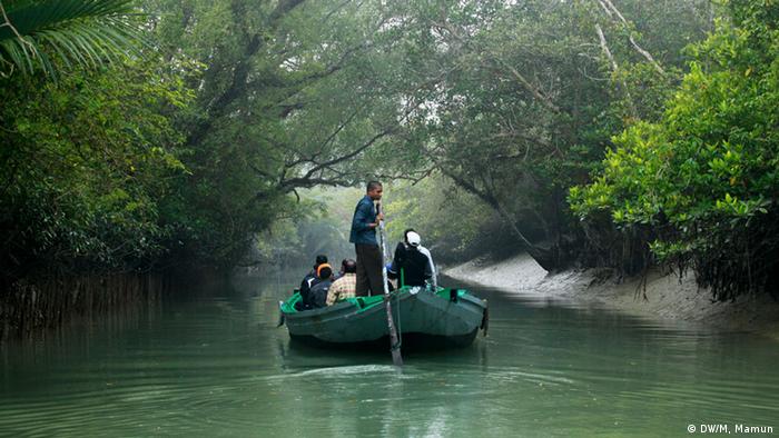
Bildergalerie Bangladesch Sundarbans Mangrovenwälder

বঙ্গোপসাগরের উপকূল ঘেঁষে পৃথিবীর সবচেয়ে বড় ম্যানগ্রোভ ফরেস্ট বা শ্বাসমূলীয় বন সুন্দরবন৷ বাংলাদেশ ও ভারতজুড়ে বিস্তৃত এ বনের মোট আয়তন প্রায় ১০,০০০ বর্গকিলোমিটার৷বাংলাদেশে সুন্দরবনের আয়তন প্রায় ৬০১৭ কিলোমিটার৷ আয়তনের প্রায় ৭০ ভাগ স্থল আর ৩০ ভাগ জল৷ পুরো সুন্দরবনের ভেতরে জালের মতো অসংখ্য নদী আর খাল রয়েছে৷ জীববৈচিত্রে ভরপুর সুন্দরবনকে ১৯৯৭ সালে ইউনেস্কো বিশ্ব ঐতিহ্যের তালিকায় অন্তর্ভুক্ত করা হয়৷ প্রায় ৪০০ প্রজাতির পাখির বসবাস এই বনে৷
শেলা নদীতে ডুবে যাওয়া তেলবাহী ট্যাংকার ‘ওটি সাউদার্ন স্টার ৭'-কে দুর্ঘটনার দু'দিন পর উদ্ধার করা হয়েছে৷ কিন্তু ট্যাংকার থেকে ৭০ কিলোমিটার এলাকায় তেল ছড়িয়ে পড়ায় সুন্দরবনের পরিবেশ ও জীববৈচিত্র্য পড়েছে চরম হুমকির মুখে৷পূর্ব সুন্দরবনের চাঁদপাই রেঞ্জের শেলা নদীতে মঙ্গলবার ভোরে মালবাহী জাহাজের ধাক্কায় তেলসহ ‘ওটি সাউদার্ন স্টার সেভেন' নামে একটি তেলবাহী ট্যাংকার ডুবে যায়৷ দুর্ঘটনা কবলিত ওই তেলবাহী ট্যাংকার থেকে আশেপাশের প্রায় ৭০ কিলোমিটার অঞ্চলে তেল ছড়িয়ে পড়ে৷
পৃথিবীর সবচেয়ে বড় ‘ম্যানগ্রোভ ফরেস্ট’ বা শ্বাসমূলীয় বন সুন্দরবন৷ এই বনের প্রধান গাছটির নাম সুন্দরী৷ আর তার থেকেই সুন্দরবনের নামকরণ৷ ঋতুতে ঋতুতে এ বনের চরিত্র বদলায়৷ তবে সুন্দরবন সবচেয়ে বেশি প্রাণবন্ত হয়ে ওঠে বর্ষাকালে৷বঙ্গোপসাগরের উপকূল ঘেঁষে সুন্দরবনে বর্ষা আসে মে মাসে আর সেই বর্ষাকাল চলে সেপ্টেম্বর পর্যন্ত৷ অবশ্য জুন মাসের মাঝামাঝি থেকে সেপ্টেম্বরের মধ্যভাগ পর্যন্ত এখানে সবচেয়ে বেশি বৃষ্টি হয়৷ সুন্দরবন অঞ্চলে বার্ষিক বৃষ্টিপাতের পরিমাণ ১৬৪০-২০০০ মিমি৷ তবে বনের পশ্চিম দিক থেকে পূর্ব দিকে বৃষ্টিপাত তুলনামূলকভাবে বেশি৷

বৃহস্পতিবার দুপুরে ট্যাংকারটি উদ্ধার করা হয়েছে৷ ট্যাংকারটি গোপালগঞ্জের একটি বিদ্যুৎ কেন্দ্রের জন্য খুলনার পদ্মা অয়েল ডিপো থেকে ৩ লাখ ৫৭ হাজার ৬৬৪ লিটার ফার্নেস অয়েল নিয়ে যাচ্ছিল৷ এ ঘটনায় ট্যাংকারের মাস্টার মোকলেসুর রহমান এখনো নিখোঁজ রয়েছেন৷

ট্যাংকার ফেটে ডুবে যাওয়ার কারণে তেল পানিতে ছড়িয়ে পড়ায়, মারাত্মক হুমকিতে পড়েছে সুন্দরবনের জীববৈচিত্র্য৷ বিশেষ করে ইরাবতী ডলফিন অধ্যুষিত এলাকায় এখন ডলফিনের বিচরণ দেখা যাচ্ছে না৷ এছাড়া জোয়ারে তেলযুক্ত পানি বনে প্রবেশ করায় গাছের গোড়ায় ও শ্বাসমূলে তেলের আবরণ লেগে তা ক্ষতির মুখে পড়ছে৷নৌ-মন্ত্রী শাজাহান খান অবশ্য জানিয়েছেন, পানির ওপর থেকে তেল দূর করতে উদ্ধারকারী জাহাজ কাণ্ডারী-১০ থেকে রাসায়নিক ছিটানো হবে৷ এতে ভেসে থাকা তেল পানির নীচে চলে যাবে এবং পানির অক্সিজেন নষ্ট হওয়ার আশঙ্কা কমবে৷ এছাড়া বন্দর কর্তৃপক্ষের হার্বার মাস্টার আকতারুজ্জামান জানান, দ্রুতই তেল অপসারণের কাজ শুরু হবে৷

ট্যাংকার দুর্ঘটনায় তেল নিঃসরণের পর সুন্দরবনে শেলা নদী রুটে সব ধরনের নৌ-যান চলাচল বন্ধের নির্দেশ দিয়েছে সরকার৷ নৌ-মন্ত্রণালয় জানায়, এক জরুরি আন্তঃমন্ত্রণালয় সভায় পরবর্তী নির্দেশ না দেওয়া পর্যন্ত শেলা নদী রুটে সব ধরনের নৌ-যান চলাচল বন্ধ রাখার সিদ্ধান্ত নেয়া হয়েছে৷
ওদিকে, তেল ছড়িয়ে পড়ার ঘটনায় দুই জাহাজ মালিকের বিরুদ্ধে ১০০ কোটি টাকার ক্ষতিপূরণ মামলা করেছে বনবিভাগ৷

Monday, October 26, 2015

Star Mosque in Dhaka


 Image result for Star Mosque in Dhaka

In a city well known for its numerous mosques, the Star Mosque (Tara Masjid) stands out as a sparkling jewel in the Armanitola area in the older part of the city of Dhaka, Bangladesh. Although the mosque has no inscription relating to the date of construction, it is known that the mosque was erected by the son of a prominent landowner (zaminder), Mirza Golam Pir who died in 1860. Therefore, it is generally agreed that the beautiful Star Mosque, which at that time was known as Mosque of Mirza Shaheb, was built in the first half of the 19th century. Star mosque, a 19th century establishment, is a very beautiful mosque of the city situated at Manitoulin, in the old part of Dhaka City. In faultless Mughal style architecture, it is a five­-dome mosque with hundreds of big and small twinkling stars as surface decorations. The stars have been created by setting pieces or chinaware on white cement. Seen from the front and from far it looks as if it were shining above the surface of the earth. The inside or the mosque is even more beautiful than the outside, with a lovely mosaic floor and excellent tiles with many floral patterns set on the walls, all in complete harmony. Whenever you want to visit the Dhaka City, don’t forget to set a visit at Star Mosque[gallery] , the Islamic Holy place. It is the perfect place where you feel comfortable and see spectacular architecture.

Saturday, October 24, 2015

Sixty dome Mosque


Image result for sixty dome mosque

The Sixty Dome Mosque Shaṭ Gombuj Moshjid) (more commonly known as Shait Gambuj Mosque or Saith Gunbad Masjid),a UNESCO World Heritage Site, is a mosque in Bangladesh, the largest in that country from the Sultanate period. It has been described as "the most impressive Muslim monuments in the whole of the Indian subcontinent. It is located in Bagerhat district in southern Bangladesh which is in the division of Khulna. It is about 3 miles far from the main town of Bagerhat. Bagerhat is nearly 200 miles away from Dhaka which is the capital of Bangladesh. The mosque has 77 squat domes with 7 four-sided pitched Bengali domes in the middle row.The vast prayer hall, although provided with 11 arched doorways on east and 7 each on north and south for ventilation and light, presents a dark and somber appearance inside. It is divided into 7 longitudinal aisles and 11 deep bays by a forest of 60 slender stone columns, from which springs rows of endless arches, supporting the domes. Six feet thick, slightly tapering walls and hollow and round, almost detached corner towers, resembling the bastions of fortress, each capped by small rounded cupolas, recall the Tughlaq architecture of Delhi.The mosque represents wonderful archeological beauty which was the signature in the 15th century. The mosque is locally known as the 'Shat Gombuj Masjid', which in Bangla means Sixty Domed Mosque. However, there are 77 domes over the main hall and exactly 60 stone pillars. It is possible that the mosque was originally referred to as the Sixty Pillared Mosque where Amud meaning column in Arabic/Persian, later got corrupted to Gombuj (গম্বুজ) in Bangla, which means domes. In mid-15th century, a Muslim colony was founded in the unfriendly mangrove forest of the Sundarbans near the coastline in the Bagerhat district by an obscure saint-General, named Khan Jahan Ali. He preached in an affluent city during the reign of Sultan Nasiruddin Mahmud Shah, then known as 'Khalifalabad'. Khan Jahan adorned this city with more than a dozen mosques, the spectacular ruins of which are focused around the most imposing and largest multidomed mosques in Bangladesh, known as the Shait-Gumbad Masjid (160'×108'). The construction of the mosque was started in 1442 and it was completed in 1459.The mosque was used for prayer purposes. It was also used as a madrasha and assembly hall.

Thursday, October 22, 2015

Bandarban District, Bangladesh.


Image result for tourist places in bandarban bangladesh


Bandarban Hill District is the most remote and least populated district in Bangladesh. The lure of the tallest peaks of Bangladesh, treks through virgin forests and chance to meet more than 15 tribes of the region up close is growing both among Bangladeshis and tourists from other countries. Since the insurgency ceased in the Chittagong Hill Tracts (a cluster that includes all three hill districts of Bangladesh) it has opened up for tourists more than a decade back, though some of the western tourist guides may still describe the area as a major security risk.Bandarban is a district in South-Eastern Bangladesh, and a part of the Chittagong Division. It is one of the three districts that make up the Chittagong Hill Tracts, the others being Rangamati District and Khagrachhari District. Bandarban is regarded as one of the most attractive travel destinations in Bangladesh. Bandarban (meaning the dam of monkeys), or in Marma or Arakanese language as "Rwa-daw Mro" is also known as Arvumi or the Bohmong Circle (of the rest of the three hill districts Rangamati is the Chakma Circle, Raja Devasish Roy and Khagrachari is the Mong Circle, Raja Sachingprue Marma). Bandarban town is the home town of the Bohmong Chief (currently King, or Raja, U Cho Prue Marma) who is the head of the Marma population. It also is the administrative headquarters of Bandarban district, which has turned into one of the most exotic tourist attractions in Bangladesh since the insurgency in Chittagong Hill Tracts has ceased more than a decade back. In the late 1970s, a policy of forced settlement of Bengalis into hills was pursued, which later gave rise to much violence against the hill people and the insurgency led by Shanti Bahini, the military wing of Parbatya Chattagram Jana Sanghati Samiti. There have been an attempt to create divide among tribal cultural lines between the Chakmas, who led Shantibanhini, and the Mrus, by creating an anti-Shantibanhini militia out of them. Now, after the peace treaty, Bandarban stands as a locally governed ethnic region together with the two other hill districts. Representation of numerous tribes of the district in the Hill Council now stands as a thorn of dispute here. 


Wednesday, October 21, 2015

Mosque City of Bagerhat, Bangladesh.

Add caption


Mosque City of Bagerhat

 The Mosque City of Bagerhat  is a formerly lost city, located in the suburbs of Bagerhat city in Bagerhat District, in the Khulna Division of southwest of Bangladesh. Bagerhat is about 15 miles south east of Khulna and 200 miles southwest of Dhaka.The history of the present-day Bagerhat is traced to the Bengal Sultanate under the rule of Sultan Nasir al-din Mahmud Shah (1442–1459. It was established by the Ulug Khan Jahan (1433–1459), an administrator under the sultanate in the 15th century; an inscription on his tomb here mentions 1459 as his date of death, testifying the construction of the city in the mid 15th century. He was responsible for establishing a planned township with roads, bridges, and water supply tanks (ponds – two are still surviving: the Ghoradighi and Dargadighi), cisterns, and a very large number of mosques and tombs, and palaces and his own mausoleum, all attributed in the same “Khan Jahan Style”; Khan Jehan lived in the town and did extensive philanthropic work.[ It is mentioned that the Delhi Sultanate, for political and religious reasons, wanted to establish an outpost of Islam in the then-remote part of India in Bengal and deputed Ulug Khan Jahan to brave this task.The historic city, listed by Forbes as one of the 15 lost cities of the world, has more than 50 Islamic monuments which have been found after removing the vegetation that had obscured them from view for many centuries. The site has been recognized as a UNESCO World Heritage Site in 1983 under criteria (iv), "as an outstanding example of an architectural ensemble which illustrates a significant stage in human history" of which the Sixty Pillar Mosque (Shat Gombuj Masjid in Bengali), constructed with 60 pillars and 77 domes, is the most well known. Apart from these monuments, UNESCO also includes the mausoleum of Khan Jahan, the mosques of Singar, Bibi Begni, Reza Khoda, Zindavir among the unique monuments.

Tuesday, October 20, 2015

Sylhet, Bangladesh


Image result for sylhet city

Sylhet is a major urban center in north-east part of Bangladesh. It is the principal city and administrative capital of Sylhet Division. The city is located on the banks of Surma River in the Barak Valley and has a population of more than 500,000 people, making it the fourth largest city in Bangladesh. Sylhet is known in Bengal as the "City of Saints". It is home to the mausoleums and mosques of Shah Jalal and Shah Poran, Bengal’s most revered Sufi saints. Every year, the city receives hundreds and thousands of pilgrims to the Dargahs of Shah Jalal and Shah Paran, earning a reputation as the "spiritual capital of Bangladesh". Sylhet is also famed for its natural setting, amidst rainforests, waterfalls, hills and river valleys.On the eve of the partition of India, the people of Sylhet voted in a referendum to join East Bengal. It became a hotbed of the Bangladeshi liberation struggle and produced many renowned freedom fighters, including leading commanders of the Freedom Fighter (Mukti Bahini). As the northeastern frontier of Bengal and its crossroads with Assam, Sylhet had developed a distinct Bengali cultural identity. This includes the distinct Sylheti Bengali dialect and Sylheti cuisine, as well as Sylheti mystic culture, which celebrates religion and pluralism in Bengal. Rabindranath Tagore, the great Bengali poet and first Asian Nobel laureate, took tremendous inspiration from these traditions, particularly from the poetry and songs of Hason Raja.The Sylhet Division produces most of Bangladesh's tea yield, fertilizer and natural gas. It is also known for its cane, citrus, timber and agar wood. Sylhet is a major recipient of remittances from the Bangladeshi diaspora, particularly from the United Kingdom. The city is served by the Osmani International Airport. It is connected to the Port of Chittagong by the N2 and the Bangladesh Railway. The Bangladesh-India border in Tamabil is located to the north of the city. Sylhet is also home to the Shahjalal University of Science and Technology. Sylhet has an international cricket stadium.

Monday, October 19, 2015

Jatiyo Sangsad Bhaban


Image result for jatiyo sangshad bhaban

There have been nine national elections in Bangladesh. The first and second Parliaments used the Old Shangshad Bhaban, which currently serves as the Prime Minister's Office.
Jatiyo Sangshad was designed by Louis Kahn. Initially, the government had appointed Muzharul Islam as the center's architect, but Islam deferred, instead recommending bringing in the world's top architects for the project. He initially attempted to bring Alvar Aalto and Le Corbusier, who were both were unavailable at the time. Islam then enlisted his former teacher at Yale, Louis Kahn.
The design of the capital complex was developed taking into account the aesthetic heritage of Bengal, particularly including the Ganges delta.
Jatiyo Sangsad Bhaban or National Parliament House, (Bengali: জাতীয় সংসদ ভবন Jatiyô Sôngsôd Bhôbôn) is the house of the Parliament of Bangladesh, located at Sher-e-Bangla Nagar in the Bangladeshi capital of Dhaka. Designed by architect Louis Kahn, the complex, is one of the largest legislative complexes in the world, comprising 200 acres (800,000 m²)
The building was featured prominently in the 2003 film My Architect, detailing the career and familial legacy of its architect, Louis Kahn. Robert McCarter, author of Fardin I. Kahn, described the National Parliament of Bangladesh as one of the twentieth century's most significant buildings.Construction began in 1961 by President Ayub Khan, the then president of Pakistan as a permanent building for the federal legislature of both West Pakistan and East Pakistan and was completed after the country's war of independence and several decades — on 28 January 1982. The complex opened the following month on 15 February for the eighth (and last) session of the second parliament of Bangladesh and has since operated as the sole complex for the National Assembly.The Complex can be accessed using any of the four roads surrounding it, however, the Manik Mia Avenue and Lake Road are the easiest approaches.

Sunday, October 18, 2015

Tourism in Bangladesh


Image result for tourism in bangladesh wikipedia


Image result for tourism in bangladesh wikipedia

Bangladesh's tourist attractions include, historical and monuments, resorts, beaches, picnic spots, forests and tribal people, wildlife of various species. In the south-western part, mainly the Khulna Division, there is the Sundarbans, the largest mangrove forest of the world with Royal Bengal Tiger and spotted deer. In the south-eastern part, which is the Chittagong Division, there are natural and hilly areas like Chittagong Hill Tracts, along with sandy sea beaches. The most notable beach, in Cox's Bazar, is a contender for the title of longest unbroken sandy sea beach in the world. Bangladesh offers ample opportunities to tourists for angling, water skiing, river cruising, hiking, rowing, yachting, sea bathing as well as bringing one in close touch with pristine nature. In the north-eastern part, Sylhet division, there is a green carpet of tea plants on small hillocks. Natural reserved forests are great attractions. Migratory birds in winter, particularly in the hair areas, are also very attractive in this area. Bangladesh offers ample opportunities to tourists for angling, water skiing, river cruising, hiking, rowing, yachting, sea bathing as well as bringing one in close touch with pristine nature. The Ministry also maintains the Beautiful Bangladesh campaign. Bangladesh Government has formed Tourist Police unit to better protect local and foreign tourists as well as look after the nature and wildlife in the tourist spots. Natural reserved forests are great attractions. Migratory birds in winter, particularly in the haor areas, are also very attractive in this area. 


Saturday, October 17, 2015

Beautiful landscape with kind people, Chittagong, Bangladesh.


 Image Courtesy : wikimedia.org/wikipedia/commons/9/94/cemetry.JPG

The beautiful landscape and kind people of Borneo motivated the cyclists on their grueling trip.
This area is very popular, mainly because of the big number of ethnic groups who are living here together. Tourists from all over the globe travel not just to enjoy the natural beauty of this place, but they also enjoy the unique experience like, dress, food, language and many other aspects of people in Chittagong.There are two main meanings for the word landscape: it can refer to the visible features of an area of land, or to an example of the genre of painting that depicts such an area of land. Landscape, in both senses, includes the physical elements of land forms such as (ice-capped) mountains, hills, water bodies such as rivers, lakes, ponds and the sea, living elements of land cover including indigenous vegetation, human elements including different forms of land use, buildings and structures, and transitory elements such as lighting and weather conditions
The beaches and lakes in Chittagong are frequently visited by western tourists as they provide a relaxing luxury at an affordable price.

Wednesday, October 14, 2015

Sonargaon, Bangladesh.


 Sonargaon, Bangladesh.

The name Sonargaon came as the Bangla version of the ancient name Suvarnagrama. Bauddha ruler Danujamadhava Dasharathadeva shifted his capital to Suvarnagrama from Bikrampur sometime in the middle of the 13th century. In early 14th century, Bauddha ruling in this area ended when Shamsuddin Firoz Shah (reigned 1301–1322) of Lakhnauti occupied and annexed it to his kingdom.
Sonargaon (Bengali: সোনারগাঁও; also transcribed as Sunārgāon, meaning City of Gold) was a historic administrative, commercial and maritime center in Bengal. Situated in the center of the Ganges delta, it was the seat of the medieval Muslim rulers and governors of eastern Bengal. Sonargaon was described by numerous historic travelers, including Ibn Battuta, Ma Huan, Niccolò de' Conti and Ralph Fitch as a thriving center of trade and commerce. It served as the capital of Sultan Fakhruddin Mubarak Shah, Isa Khan and the Baro-Bhuyan Confederacy. The area is located near the modern industrial river port of Narayanganj in Bangladesh. Today, the name Sonargaon survives as the Sonargaon Upazila (Sonargaon Subregion) in the region.Panam City was established in the late 19th century as a trading center of cotton fabrics during British rule. Hindu cloth merchants built their residential houses following colonial style with inspiration derived from European sources. Today this area is protected under the Department of Archaeology of Bangladesh. The city was linked with the main city area by three brick bridges - Panam Bridge, Dalalpur Bridge and PanamNagar Bridge - during the Mughal period. The bridges are still in use.By the 14th century Sonargaon became a commercial port. Trade activities were mentioned by travelers like Ibn Batuta, Ma Huan and Ralph Fitch. Maritime ships traveled between Sonargaon and southeast/west Asian countries. Muslin was produced in this region.